The Puerto Rico trench hazard could someday result in a horrific collapse, a submarine landslide, and would produce a tremendous tsunami in the region which would spread widely across that part of the Atlantic ocean.

The National Oceanic and Atmospheric Administration (NOAA) states that the Puerto Rico Trench is the deepest part of the Atlantic Ocean, with water depths exceeding 5.2 miles! The Puerto Rico Trench is also associated with the most negative gravity anomaly on earth, -380 milliGal, which indicates the presence of an active downward force.
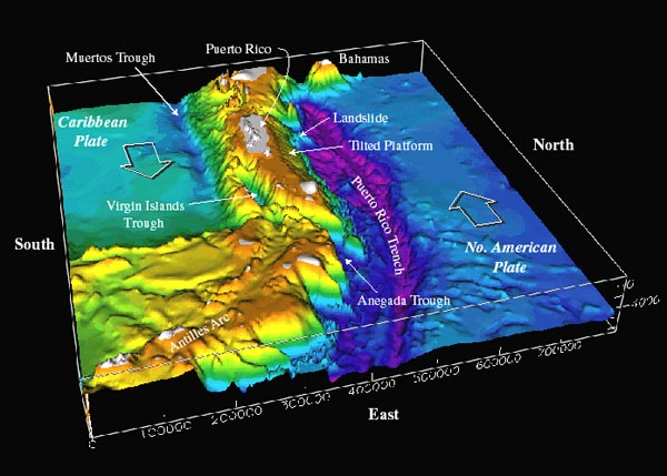
The region is located on an active plate boundary zone between the North American plate and the northeast corner of the Caribbean plate. The North American tectonic plate is descending under Puerto Rico and the Virgin Islands, south of the trench.
The results of studies involving mapping and seismic profiling of the sea floor off Puerto Rico’s northern shore, have uncovered evidence of an enormous submarine landslide. The the suspect slide extends across roughly 35 square miles, and evidence indicates that a slide of this size would have involved approximately 620 cubic miles of material!
Assuming that the slide occurred as a single event, an underwater slide of this magnitude would have generated a tsunami of frightening proportions. The effects of such a tsunami on present day Puerto Rico would be disastrous, and considering that the region is still tectonically active, an event like this could likely occur again at some point in the future.
In addition to the sure disaster that would unfold in Puerto-Rico, the British Virgin Islands, and other regional islands, I wonder how such a tsunami would affect the state of Florida, although 1,000 miles away, it’s only barely above sea level. Ken, Modern Survival Blog
 |
| Figure 1 |
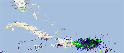
Looking at some of the historical earthquakes in the region as reported from the IRIS earthquake monitor, there is an obvious region of very high earthquake activity off the coast of Puerto Rico which itself is located along a very steep seafloor ridge or trench. Could we be looking at an eventual disaster in this region?
Puerto Rico, the Virgin Islands to its east, and eastern Hispaniola to its west, are located on an active plate boundary zone between the North American plate and the northeast corner of the Caribbean plate (figure 1). The Caribbean plate is roughly rectangular, and it slides eastward at about 2 cm/yr relative to the North American plate. Motion along its northern boundary (in the plate boundary zone region) is dominantly strike-slip (a geological fault in which an adjacent surface moves horizontally), with a small component of shortening. In contrast, on its eastern boundary, the Caribbean overrides the North American plate, creating the island arc of the Lesser Antilles with its active volcanoes.
 |
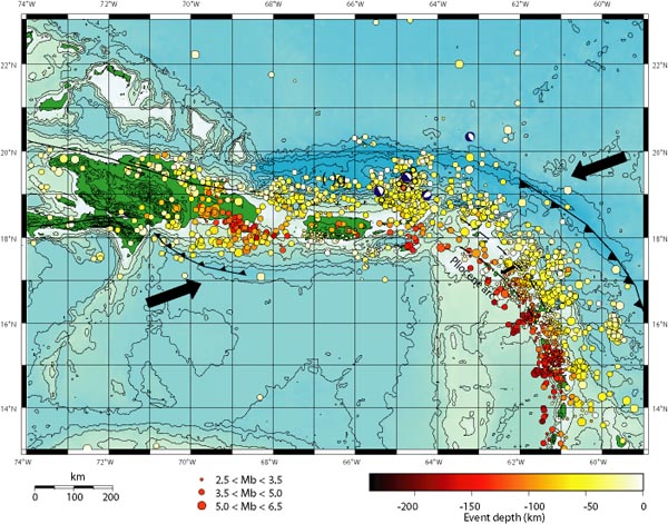
Figure 2. Location of earthquakes as a function of depth and size in the northeastern Caribbean. Zen Gardner: “What Puerto Rico Trench?” Exactly. The arrows in the map above show the direction the underlying Caribbean tectonic plates are moving, with the resultant build-up of pressure releasing into a myrid of earthquakes in the region over the years. Puerto Rico is the smaller green island in the middle, with the Dominican Republic the larger island to the left. The string of other Caribbean islands is buried under the earthquake markers that flow down the page to the lower right. You can see the Puerto Rico Trench wraps around the entire zone. A few little known facts came to the fore as I was researching this area after spotting the recent increase in seismic activity in the Caribbean region. 1. The Puerto Rico Trench is the biggest and deepest such trench in the entire Atlantic ocean. 2. This trench is capable of producing 8.0 earthquakes and above. 3. The risk of a major quake, underwater landslide and mega tsunami are as great as that of the Seattle area. In fact, one recent risk assessment put it at 35 to 55%! 4. The zone hasn’t ruptured in over 200 years and that has geologists seriously concerned. In other words, something major will happen. No one knows when, but it will happen,as it has in the past there. Add that to the fact that 35 million people live in surrounding low lying areas and you have a monumental disaster just waiting to happen. But Why No Warning?What struck is that in everything I’m reading, it’s admitted this risk is huge but it’s hardly known in the area. Even Wikipedia admits:
Why? Would it negatively impact the local economy, much like the idiot mayor’s development worries in the movie Jaws? Are there really such people in charge? Well, look at the Gulf oil disaster and Fukushima for starters. I don’t think the concern is anyone’s health or well being – it’s preserving the status quo while the disasters take their toll as quietly as possible. Remember–it’s not crisis prevention, it’s crisis management. |
More from Ken:
Have a plan how you would escape to higher ground, or further inland. If you’ve already thought about it and planned a route, and you recognize the onset of the tsunami, so long as you beat the crowd you will probably be OK. Know how to recognize that a tsunami is about to happen (major earthquake while on the coast – or water withdrawing rapidly away from the coast).
The regions of earth’s crustal magnetism that have negative field strength boundaries that are directly adjacent to positive field strength areas, may or may not have any real-world effects, but it is interesting to look at and to think about how it may relate with other geophysical attributes of the region.
Contributing sources:
Modern Survival BlogOcean Explorer Noaa
Iris Seismic Monitor
Massive Puerto Rico Trench Awakening?
USGS
Survive Anything - Disasters - Economy Collapse - Tsunami - Mobs, Etc.Protect your family!
37 Food Items that will be SOLD OUT after Crisis: Prepare!
Out of a Job? Need Money? Try the LETS GET SOCIAL Program
Ping your blog


The Government of PR just last year enacted a TSUNAMI WARNING SYSTEM for the island, so they are very aware of the danger.
ReplyDeleteIn Humacao they started to put the signs but that's it, mo information is given.
ReplyDelete