Oroville Dam UPDATE 3/5/2017 - THIS IS NOT DONE YET
Another Portal to Hell in California
Tuesday, February 28, 2017 9:27
Demonic and ‘alien’/UFO activity is absolutely on the rise. The spirits are in a frenzy, knowing their time for utter chaos is at the door.
The Crowley / L Ron Hubbard connnection to Devils Gate in California! Conjuring of demonic spirits resulting in murder and other satanic activity. This is dangerous stuff.
Can we expect anything less from California? There is so much evil in that state.( 2 cor.4:3,4).The witches met out there to put a hex on Trump.Hillery is also a witch that attends on a regular basis.
Some Believe The Devil’s Gate In California Could Be A Portal To Hell
Beginning with the first people who inhabited Pasadena’s Arroyo Seco, there have been rumors of a spiritual connection to the place. The Tongva believed water running through the gorge sounded like laughter, which they attributed to the coyote spirit.
In the 1920s, the narrowest place in the Arroyo Seco was dammed to control flooding, and it was named Devil’s Gate Dam, for the demon-like face of a horned figure in the natural rock outcropping. Pictured: Devil’s Gate Dam.
In the 1940s, a group of occultists became interested in the area and attempted rituals intended to open a #portaltoHell. Pictured: The face in the rock at the beginning of this post.
The group included rocket scientist Jack Parsons (a follower of Aleister Crowley’s Thelema) and L. Ron Hubbard (future founder of Scientology). Their goal was to bring forth a “moonchild,” which they hoped would be an Antichrist figure that would lead a Thelemic revolution. Pictured: Jack Parsons.
Some people believe the rituals Parsons led in the area opened a portal to Hell and made the area a magnet for all kinds of dark activity. Devil’s Gate Dam continues to draw the attention of people interested in paranormal investigation. The face in the rock remains, silently holding its secrets, the laughter of the water providing no clues to what it may have seen.
well, mb333 had always been non speculative fact based reporting since I followed him. surprise to see him touch on nephilim and giants which is way cool.
Published on Feb 17, 2017 bySend Rain - In this video, I've done a little of my own connecting the dots and find it strange how it all seems to have some hidden meaning.
A lot of them out there hate God's anointed one and scoff at him. They lie.
They make rude remarks. This is exactly how it works when someone makes a choice to serve the Lord.
That's when the persecution starts. So many evil manifestations through their mouths. They are hypocrites. They hate us for standing our ground against our enemy. Looking at Meryl Streep and her reasoning for why she feels Trump is not good enough to lead the nation seems to be all about herself and Hollywood as she points out that there will be nothing to watch except sports. I have found plenty of things to watch that aren't Hollywood produced.
California Needs Our Prayers (Speaker Mark Taylor)
California Signed The Petition! (Strange Location Coincidences)
Published on Feb 21, 2017 by Send Rain
A few weeks ago, I saw news about California to sign for secession to be independent and break away from the US. I looked it up online and saved the front page of their petition website to make a different video. When I was looking through my files today, I found it and looked into it again and was shocked by what seems to be a strange coincidence.
75% Chance March Earthquake Southern Ca. 2-Mile Long Crack In Arizona Desert
Published on Jan 27, 2017 by Mary Greeley
Southern California is 150 years over due for a large earthquake.
Are you prepared?
Read more about his 2 mile long crack in the desert here, http://marygreeley.com/?page_id=45429
GIGANTIC Spillway Damage At Oroville - Race On To Save Dam Powerhouse
FLOOD WARNING
NATIONAL WEATHER SERVICE SACRAMENTO CA
757 PM PST SUN FEB 19 2017
...The National Weather Service in Sacramento has issued a Flood
Warning for the following rivers in California...

  Cosumnes River At Michigan Bar
...The Flood Warning continues for the following rivers in
California..
  San Joaquin River Near Vernalis
...The Flood Warning continues for the following rivers in
California...

  Tuolumne River At Modesto

.High water conditions will continue on the lower San Joaquin
River system for the next several days. Renewed rises will develop
on the Cosumnes River as inflows increase with incoming storm
systems.

Forecasts are based on present and forecasted meteorological and
hydrologic conditions at time of issuance.

PRECAUTIONARY/PREPAREDNESS ACTIONS...

Unlisted forecast points are expected to remain below monitor stage.
All those affected by river conditions should remain alert for rapid
changes and for possible forecast revisions.

For more hydrologic information and stage definitions refer to the
following web site:  http://www.wrh.noaa.gov/sto/hydro_data.php


The next statement will be issued Monday February 20, 2017 at 300 AM.

&&

CAC005-017-067-210556-
/O.NEW.KSTO.FL.W.0042.170220T2348Z-000000T0000Z/
/MHBC1.1.ER.170220T2348Z.170221T0300Z.000000T0000Z.NO/
757 PM PST SUN FEB 19 2017

The National Weather Service in Sacramento has issued a

* Flood Warning for
  The Cosumnes River At Michigan Bar.
* from Monday afternoon until further notice...Or until the warning
  is cancelled.
* At  6:30 PM Sunday the stage was 6.6 feet.
* Minor flooding is forecast.
* Forecast to rise above monitor stage of 7.0 FT early tomorrow
  morning then expected to rise above flood stage of  12.0 FT
  tomorrow afternoon then forecast to rise to near  13.0 FT tomorrow
  evening with continued rise expected.
* Flood stage 12.0 ft
* Monitor stage 7.0 ft
* Impact...Near 12.0 feet, Water flows on to the road near Wilton.
* Impact...Near 8.0 feet, Low lying lands along the river begin to
  flood.

 &&

LAT...LON 3848 12133 3859 12103 3842 12092 3836 12124


$$
Flood Warning
FLOOD STATEMENT
NATIONAL WEATHER SERVICE SACRAMENTO CA
353 PM PST SUN FEB 19 2017

...The Flood Warning continues for the following rivers in
California...

  Clear Lake At Lakeport
  Yolo Bypass Near Lisbon

.Flooding will continue at Clear Lake and at the Yolo Bypass through
at least Tuesday, and likely through the rest of the week due to
additional storms. Rises and higher stream flows are also forecasted
on the Lower Sacramento River System through Tuesday and into Wednesday.

Forecasts are based on present and forecasted meteorological and
hydrologic conditions at time of issuance.

PRECAUTIONARY/PREPAREDNESS ACTIONS...

Unlisted forecast points are expected to remain below monitor stage.
All those affected by river conditions should remain alert for rapid
changes and for possible forecast revisions.

For more hydrologic information and stage definitions refer to the
following web site:  http://www.wrh.noaa.gov/sto/hydro_data.php


The next statement will be issued Sunday, February 19, 2017 at p PM PLT.

&&

CAC095-113-210152-
/O.CON.KSTO.FL.W.0020.000000T0000Z-000000T0000Z/
/LSBC1.1.ER.170208T1540Z.170212T0815Z.000000T0000Z.NO/
353 PM PST SUN FEB 19 2017

The Flood Warning continues for
  The Yolo Bypass Near Lisbon.
* At  3:15 PM Sunday the stage was 22.1 feet.
* Minor flooding is occurring and Minor flooding is forecast.
* Forecast to fluctuate near 22.0 FT thru near tomorrow midnight then
  forecast to rise to near  22.0 FT Tuesday afternoon with continued
  rise expected.
* Flood stage 19.0 ft
* Monitor stage 13.0 ft
* Impact...Near 22.5 feet, Kerney Ranch house floods.
* Impact...Near 19.0 feet, Mound Farms and Senator Outing Duck Club
  are flooded.
* Impact...Near 16.0 feet, Glide In Ranch is completely flooded.
* Impact...Near 15.0 feet, County Road 155 is flooded west of the
  Golden Sprig Duck Club.
* Impact...Near 14.0 feet, Skyrakers Duck Club ponds begin to flood.
* Impact...Near 13.0 feet, Flood waters extend approximately 1 mile
  west of the tow drain downstream of the Lisbon gage.
* Impact...Near 12.0 feet, County Road 107 is flooded.
* Impact...Near 11.0 feet, Glide In Ranch & Mound Farms begin to
  flood.
* Impact...Near 10.5 feet, Local roads on the east side of the Yolo
  Bypass south of the I-80 causeway are flooded.
* Impact...Near 9.5 feet, Yolo Bypass flooding extends 1/4 mile west.
  No structural damage is occurring.

 &&

LAT...LON 3878 12176 3879 12156 3854 12156 3820 12164
      3822 12182

$$
Wind Advisory
URGENT - WEATHER MESSAGE
National Weather Service Sacramento CA
318 PM PST Sun Feb 19 2017

...Strong winds over northern California the next couple of
days...

.A strong Pacific storm will bring potentially damaging winds to
northern California as it approaches and moves through the region.
Breezy winds today and Monday will peak Monday evening through the
night as this system pushes through. Downed trees and widespread,
long-lasting power outages are likely especially Monday evening.
Blowing debris hazards are also possible.

CAZ017>019-201400-
/O.UPG.KSTO.HW.A.0002.170221T0300Z-170221T0900Z/
/O.NEW.KSTO.HW.W.0004.170221T0000Z-170221T1200Z/
/O.EXT.KSTO.WI.Y.0020.170220T1800Z-170221T0000Z/
Southern Sacramento Valley-Carquinez Strait and Delta-
Northern San Joaquin Valley-
Including the cities of Sacramento, Fairfield/Suisun, Stockton,
and Modesto
318 PM PST Sun Feb 19 2017

...WIND ADVISORY NOW IN EFFECT FROM 10 AM TO 4 PM PST MONDAY...
...HIGH WIND WARNING IN EFFECT FROM 4 PM MONDAY TO 4 AM PST
TUESDAY...

The National Weather Service in Sacramento has issued a High Wind
Warning, which is in effect from 4 PM Monday to 4 AM PST Tuesday.
The High Wind Watch is no longer in effect.

* TIMING...Gusty winds this evening and Monday will maximize
  Monday evening. Winds will decrease overnight Monday with
  relatively light breezes on Tuesday.

* WINDS...Winds increasing to 20 to 30 mph with gusts to 45 mph by
  late Monday morning. Winds peaking Monday evening into early
  Tuesday morning, with gusts of 50 to 65 mph.

* IMPACTS...Downed trees, blowing debris, and widespread,
  potentially long-lasting power outages.

PRECAUTIONARY/PREPAREDNESS ACTIONS...

A High Wind Warning means a hazardous high wind event is expected
or occurring. Sustained wind speeds of at least 40 mph or gusts
of 58 mph or more can lead to property damage.

A Wind Advisory means that winds of 35 mph are expected. Winds
this strong can make driving difficult, especially for high
profile vehicles. Use extra caution.

&&

Interact with us via social media
www.facebook.com/nws.sacramento
www.twitter.com/nwssacramento

$$
High Wind Warning
URGENT - WEATHER MESSAGE
National Weather Service Sacramento CA
318 PM PST Sun Feb 19 2017

...Strong winds over northern California the next couple of
days...

.A strong Pacific storm will bring potentially damaging winds to
northern California as it approaches and moves through the region.
Breezy winds today and Monday will peak Monday evening through the
night as this system pushes through. Downed trees and widespread,
long-lasting power outages are likely especially Monday evening.
Blowing debris hazards are also possible.

CAZ017>019-201400-
/O.UPG.KSTO.HW.A.0002.170221T0300Z-170221T0900Z/
/O.NEW.KSTO.HW.W.0004.170221T0000Z-170221T1200Z/
/O.EXT.KSTO.WI.Y.0020.170220T1800Z-170221T0000Z/
Southern Sacramento Valley-Carquinez Strait and Delta-
Northern San Joaquin Valley-
Including the cities of Sacramento, Fairfield/Suisun, Stockton,
and Modesto
318 PM PST Sun Feb 19 2017

...WIND ADVISORY NOW IN EFFECT FROM 10 AM TO 4 PM PST MONDAY...
...HIGH WIND WARNING IN EFFECT FROM 4 PM MONDAY TO 4 AM PST
TUESDAY...

The National Weather Service in Sacramento has issued a High Wind
Warning, which is in effect from 4 PM Monday to 4 AM PST Tuesday.
The High Wind Watch is no longer in effect.

* TIMING...Gusty winds this evening and Monday will maximize
  Monday evening. Winds will decrease overnight Monday with
  relatively light breezes on Tuesday.

* WINDS...Winds increasing to 20 to 30 mph with gusts to 45 mph by
  late Monday morning. Winds peaking Monday evening into early
  Tuesday morning, with gusts of 50 to 65 mph.

* IMPACTS...Downed trees, blowing debris, and widespread,
  potentially long-lasting power outages.

PRECAUTIONARY/PREPAREDNESS ACTIONS...

A High Wind Warning means a hazardous high wind event is expected
or occurring. Sustained wind speeds of at least 40 mph or gusts
of 58 mph or more can lead to property damage.

A Wind Advisory means that winds of 35 mph are expected. Winds
this strong can make driving difficult, especially for high
profile vehicles. Use extra caution.

&&

Interact with us via social media
www.facebook.com/nws.sacramento
www.twitter.com/nwssacramento

$$
Flood Warning
Flood Statement
National Weather Service Sacramento CA
959 AM PST SUN FEB 19 2017

CAC003-005-007-009-011-017-021-033-035-057-061-063-067-077-089-091-
095-099-101-103-109-113-115-240000-
/O.CON.KSTO.FA.W.0011.000000T0000Z-170224T0000Z/
/00000.0.ER.000000T0000Z.000000T0000Z.000000T0000Z.OO/
Colusa CA-Yolo CA-Sutter CA-Solano CA-Plumas CA-Alpine CA-Placer CA-
Shasta CA-Lassen CA-Amador CA-Tuolumne CA-Sacramento CA-Lake CA-
Stanislaus CA-San Joaquin CA-El Dorado CA-Calaveras CA-Tehama CA-
Butte CA-Glenn CA-Sierra CA-Yuba CA-Nevada CA-
959 AM PST SUN FEB 19 2017

...A FLOOD WARNING FOR URBAN AREAS AND SMALL STREAMS REMAINS IN
EFFECT UNTIL 400 PM PST THURSDAY FOR COLUSA...YOLO...SUTTER...
SOLANO...PLUMAS...ALPINE...PLACER...SHASTA...LASSEN...AMADOR...
TUOLUMNE...SACRAMENTO...LAKE...STANISLAUS...SAN JOAQUIN...EL
DORADO...CALAVERAS...TEHAMA...BUTTE...GLENN...SIERRA...YUBA AND
NEVADA COUNTIES...

* Interior Northern California will experience another significant
  uptick in flooding problems starting late tonight and continuing
  through Monday night as an intense Atmospheric River type storm
  arrives.

* Our entire region has saturated soils and many flooded areas
  already.  This will enhance the impact of additional heavy rains
  this week.

* Additional stress will be placed on levees, rivers, creeks, and
  streams.

* We may see flooding in locations which haven`t been impacted in
  many years.

* We are strongly advising all residents in interior Northern
  California to be prepared for flooding.

PRECAUTIONARY/PREPAREDNESS ACTIONS...

Be prepared to evacuate if flooding should affect your area.  Gather
a "go bag" with important items like medications and hard to replace
documents.  Do not forget to plan for you pets and animals.

Please never drive across flooded waters and roadways, especially
flowing water.  Most people who are killed or injured during floods
are attempting to drive through flooded waters.  Turn around, don`t
drown!

LAT...LON 3725 12146 3810 12157 3808 12230 3832 12206
      3884 12229 3867 12262 3907 12309 3950 12306
      3955 12288 4033 12307 4058 12269 4117 12246
      4118 12250 4118 12133 4059 12132 3835 11963
      3776 11988 3780 12018 3713 12122

$$

MK
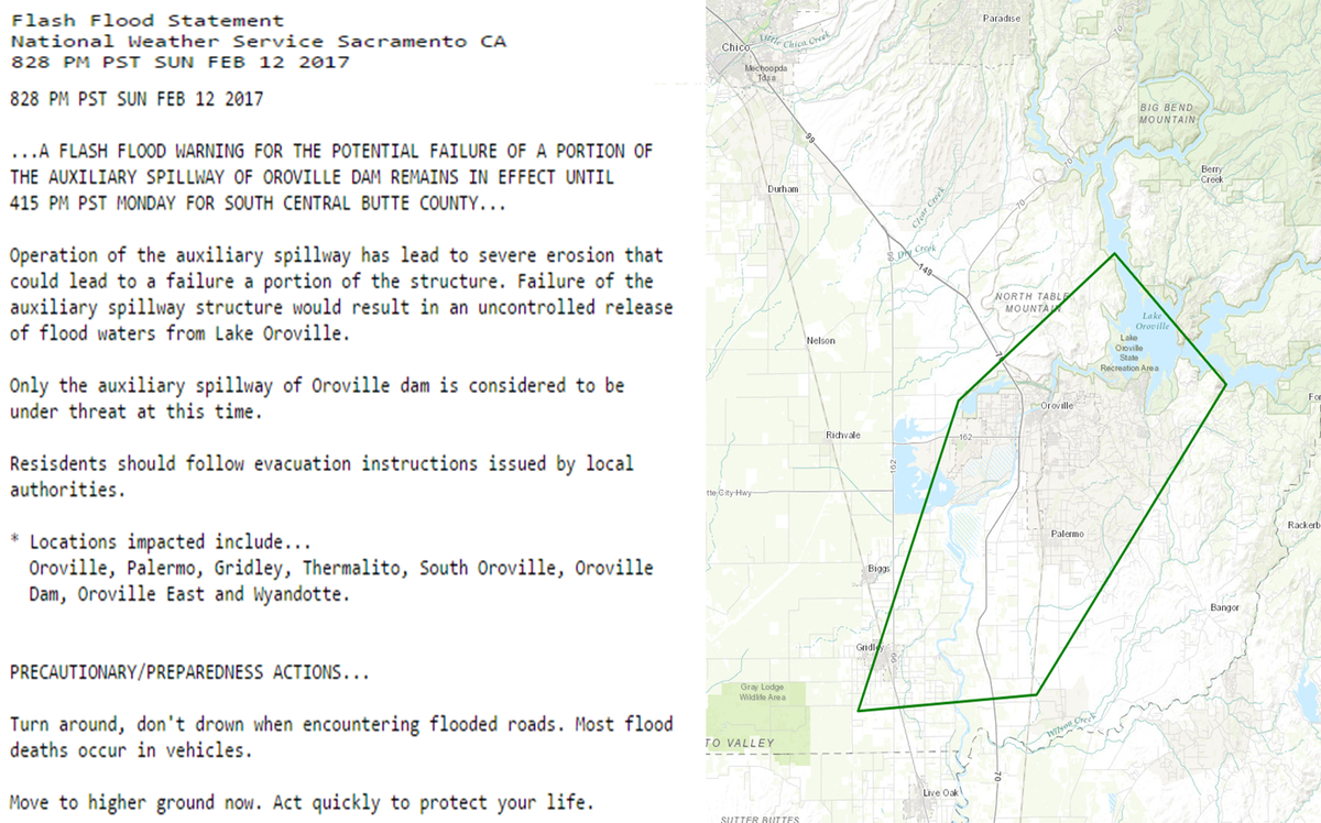
'Hazardous situation' has developed with Oroville Dam emergency spillway "Officials are anticipating a failure of the Auxiliary Spillway at Oroville Dam within the next 60 minutes (5:45 p.m.)," the California Department of Water Resources said on Facebook.
"A hazardous situation is developing with the Oroville Dam auxiliary spillway," the sheriff's office said on its Facebook page. "Operation of the auxiliary spillway has (led) to severe erosion that could lead to a failure of the structure. Failure of the auxiliary spillway structure will result in an uncontrolled release of flood waters from Lake Oroville."
You may have slept through last night's 4.0 magnitude earthquake, but at least one U.S. Geological Service scientist wants to make sure you don't sleep again.
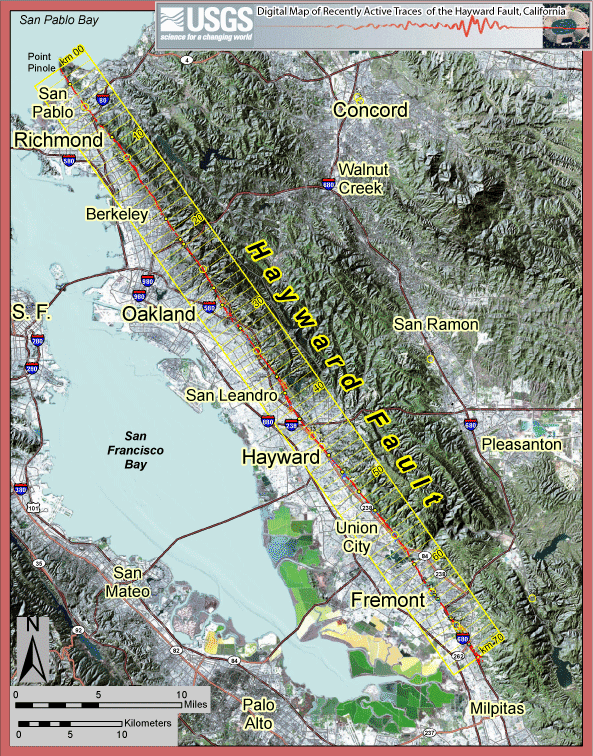
Tom Brocher, a scientist with the USGS, told CBS that the Hayward Fault, which produced last night's trembles, is due to produce a major earthquake "any day now."
“The population is now 100 times bigger in the East Bay, so we have many more people that will be impacted,” said Tom Brocher, a research geophysicist with the USGS.
“We keep a close eye on the Hayward Fault because it does sit in the heart of the Bay Area and when we do get a big earthquake on it, it’s going to have a big impact on the entire Bay Area,” Brocher said.
While a 2008 report put the probability of a 6.7-magnitude or larger earthquake on the Hayward-Rodgers Creek Fault system over the next 30 years at 31 percent, Brocher said the reality is a major quake is expected on the fault “any day now.”
“The past five major earthquakes on the fault have been about 140 years apart, and now we’re 147 years from that 1868 earthquake, so we definitely feel that could happen any time,” Brocher said.Bocher has been sounding the alarm on the Hayward Fault for a while now. In 2008, he was the lead author of a USGS report that described the fault as a "tectonic time bomb" and warned that a 6.8-7.0 magnitude quake could "could cause hundreds of deaths, leave thousands homeless, and devastate the region’s economy." Among the factors that lead the report's authors to suggest that the Hayward Fault is the country's most dangerous one are the facts that it is the "single most urbanized earthquake fault in the United States" and that "critical regional gas and water pipelines and electrical transmission lines cross." You can read the full reporthere [pdf].
And if that doesn't freak you out enough, have you checked out the USGS liquefaction maps for your neighborhood? About 25% of the Bay Area is considered to have Very High, High or Moderate susceptibility to liquefaction.
Sweet dreams.
USGS Screenshot of the USGS liquefaction map. Follow the link to zoom in on your hood.
7/23/2015 -- West Coast LARGE Earthquake Warning -- USGS quote "any day now"
Earlier this month i believe msnbc, mightve been another network, sent out a message (one of those bottom of the screen scrollers) that said 9.0 quake hits bay area....literally at the same time frame as this
...
Ive been corrected...it was CNN...which is no more surprising :P
There are seashells to be found, along with the arrow heads....just under the topsoil in Arizona, at 5000 ft in elevation, along the Mogollon Rim...
A bit off topic, but this was just in case people have trouble believing these places were under water, NOT so long ago....
...and they will be again.
+kittensugars In Canon City, Colorado, if you go on top of the scenic drive, there are ocean fossils at eye level and a little marker explaining them, kinda cool if you are nearby.
I wonder if there has been any lift of the ground around those old volcanoes? Dutch I think you are "the sht" by the way, and I, for one, have learned a lot from you. Thank you for what you do. ~Me The People
I also wonder if some of these "hot spots' similar to the kind melting the road up in yellow stone could be starting some of those fires. Because looking at the RSOE there's fires all around the caldera
Sirius begins rising NOW on the Giza plateau.
August 6th to 10th is the next CRITICAL quake window... just weeks away.
The clash of the Kings (Jupiter & Regulus) is on our doorstep!
+Enterthe5t4rz ANY DAY NOW =122 in simple gematria San Francisco=122 ANY DAY NOW also =732 in english gematria
732+237=969 9.69 km/s is the orbital speed of Saturn.
Even the date 23/7 is in the english gematria
Dont know what this all means
2+3=5 7 57 mirror 75 7 2+3=5 75
5775 we are in the hebrew year 5775
+Rita 511 You've got some CRAZY numerology. If I looked up "gematria" would I get an explanation of how this works. I'd be more on board, I would say Sept 24th., This is getting VERY INTERESTING...!!!
A continuation of the previous Report of movement in our Earth's Crust and Earthquake warnings from the Dutchsinse Channel. Dutch also talks about the USGS West Coast warning and the precursor movements happening in the Area.
Peace Y
During the July 10th Today Show on CNN a news ticker all of a sudden reported, "Massive 9.0 earthquake hits Bay Area" and then quickly disappeared. July 10th on the Julian calendar is July 23rd on the Gregorian calendar. July 10th is the 191st day of the year. On July 23rd there will be 161 days remaining until the end of the year. 191 is the reflection of 161.
USEFUL “STUFF”:
Recommended Products Below.
If You Click Them, We Earn A Small Commission. Your Price Doesn’t Change, But This Commission Helps Support The Work Of Running This Site. Thanks For Your Support.
Global Rumblings depends heavily
upon the the support that you provide
by clicking on and purchasing products
that are advertised here. Without your
support, this site could not sustain
itself because it takes time and money
to stay on the internet. Thank You!







 Posts
Posts


