
Showing posts with label severe storms. Show all posts
Showing posts with label severe storms. Show all posts
Friday, June 02, 2017


Monday, July 13, 2015
Huge Storm Over 700 Miles-Still Going Strong

http://www.spc.noaa.gov/
 | SEVERE THUNDERSTORM 0419 – Valid until: 07/14/2015 0900Z – States affected: IL IN KY OH |
http://globalrumblings.blogspot.com/2015/07/climate-change-skeptics-gather-in-dc.html
USEFUL “STUFF” SEARCH DISCLOSURE :
Recommended Affiliate Products Below.
If You Click Them, We Earn A Small Commission. Your Price Doesn’t Change, But This Commission Helps Support The Work Of Running This Site. Thanks For Your Support.
SURVIVE THE END DAYS - What is happening now? What will happen? How can you survive? Click Here.
Swanson Vitamins for High Quality, and Low Prices! Get Discounts! $5.00 Coupon
ShapeFast Ultra has DR.OZ's Recommended Weight Loss FORSKOLIN! 4Life's ShapeFast Ultra
***Snake Venom for Chronic Pain Relief?? And for Dogs and Cats too! ***
You've got to be kidding! Click to See
Survive Anything - Disasters - Economy Collapse - Mobs, Etc. PROTECT YOUR FAMILY Click Here!
37 Food Items that will be SOLD OUT after Crisis:

Ping your blog
Build a shelter, a shed, a little house - Click Here for Instant access to over 12,000 plans
Tuesday, June 23, 2015
Radio Blackout-Severe Geomagnetic Storm

A geomagnetic storm hit Earth Monday as energy from a series of solar explosions reached Earth’s magnetic field — and space weather forecasters say it could be a multi-day event.

NOAA map shows radio disturbances on Earth from the geomagnetic storm. (NOAA)
NOAA’s Space Weather Prediction Center (SWPC) said the magnetic storm, which is forecast to hit a "severe" G4 level, slammed into Earth a little before 3 p.m. EDT Monday.
The solar activity is the result of the sun releasing a series of coronal mass ejections (CMEs), which NASA describes as “huge explosions of magnetic field and plasma from the Sun’s corona.”
NASA’s Solar Dynamics Observatory recorded a CME June 18, a second on June 19, and then a third on June 21. Energy from the third CME traveled swiftly enough to join the previous two.

The Geophysical Institute at the University of Alaska Fairbanks outlines the best chances to see the aurora in North America. (Geophysical Institute/University of Alaska)
Spaceweather.com reports there was a “moderately strong blackout of shortwave and low-frequency radio signals over North America,” and that the Earth’s poles were experiencing a deeper blackout. A blackout map from NOAAshows the reach of the blackouts.
Radio distruptions aren’t the only way the storm could impact Earth. Skywatchers in Europe and the U.S. are likely to see dazzling Northern Lights displays much further south than average.
The Geophysical Institute of the University of Alaska at Fairbanks said the aurora could be visible in a long stripe of the U.S. from Alaska into the Pacific Northwest, the Upper Midwest, Great Lakes and New England. Scientists said there was a chance people as far south as Oklahoma City and Raleigh, North Carolina, could get a glimpse of the lights.
Astronauts at the International Space Station were already taken aback by the celestial show. Scott Kelly excitedly tweeted a photo of a red hue pulsing around the Earth, exclaiming, "I've never seen this before -- red aurora. Spectacular!"

Astronaut Scott Kelly took this photo from the International Space Station as the geomagnetic storm hit Earth Monday. (Astronaut Scott Kelly/NASA)
“This is the very early stages of an event that will play out over many hours,” SWPC forecasters said of the geomagnetic storm.
SWPC predicts the storm could last into Tuesday, and could possibly reach the intensity of a similar storm in March, which allowed people into the Tennessee Valley and Upper Midwest to spot the Northern Lights.
MORE ON WEATHER.COM: Astronaut Samantha Cristoforetti’s Pictures from Space
Severe Thunderstorm Threat Reaches the Northeast Tuesday (FORECAST)
The threat of severe thunderstorms with damaging winds, hail, and perhaps a few tornadoes reaches the Northeast Tuesday, including the heavily-populated Interstate 95 corridor. Other severe storms may erupt over parts of the Ohio Valley, Missouri Valley, and Plains.
The Storm Prediction Center tallied 13 reports of tornadoes Monday, primarily in northern Illinois and southeast Lower Michigan. National Weather Service staff will perform damage surveys Tuesday to confirm (or classify as straight-line winds) and rate the intensity of Monday's tornadoes.
One possible tornado caused damage in the Woodhaven Lakes development west of Sublette, Illinois with reports of people trapped inside trailers. In Millington, Michigan another possible tornado destroyed a house and in Grundy County, Illinois a building collapsed with people trapped.
Monday morning, winds over 70 mph battered parts of South Dakota, southern Minnesota and northern Iowa as a derecho, a long-lived squall line of severe thunderstorms, roared through before weakening over southern Wisconsin and northern Illinois shortly before lunchtime.
SURVIVE THE END DAYS - What is happening now? What will happen?
How can you survive? Click Here.
Swanson Vitamins for High Quality, and Low Prices! Get Discounts! $5.00 Coupon
ShapeFast Ultra has DR.OZ's Recommended Weight Loss FORSKOLIN! 4Life's ShapeFast Ultra
***Snake Venom for Chronic Pain Relief?? And for Dogs and Cats too! ***
You've got to be kidding! Click to See
Survive Anything - Disasters - Economy Collapse - Mobs, Etc. PROTECT YOUR FAMILY Click Here!
37 Food Items that will be SOLD OUT after Crisis:
Ping your blog
Build a shelter, a shed, a little house - Click Here for Instant access to over 12,000 plans
Thursday, June 05, 2014
Tornadoes, severe storms expected Tuesday
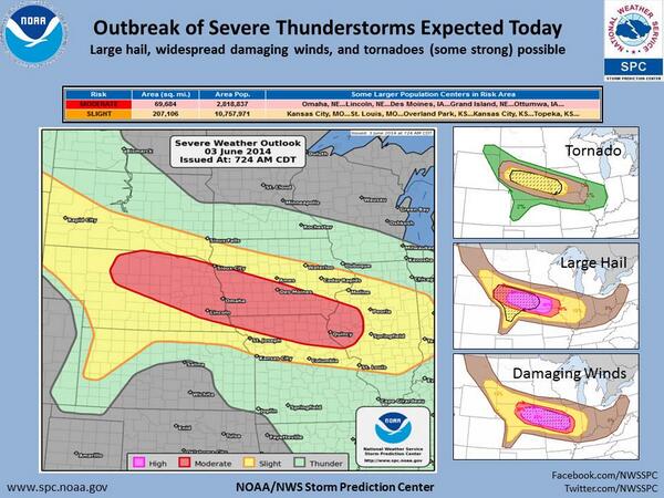
People in at least six states from the Plains to the Midwest are bracing for dangerous storms thatforecasters say could produce hurricane-force winds, very large hail and a few "intense" tornadoes beginning late Tuesday afternoon.

According to the National Weather Service's Storm Prediction Center in Norman, Okla., the severe weather outbreak is expected to stretch from southern South Dakota through Nebraska, Kansas, southern Iowa, northern Missouri and west-central Illinois.
Forecasters predict that damaging winds — 60-80 mph in some places — and large hail will be widespread.
"It's called a 'land hurricane,' and one could develop tonight across the Plains," CBS Chicago's Megan Glaros tweeted.
According to Accuweather.com, the storms will be accompanied by heavy rain (2 to 4 inches) that could cause flash flooding in some areas.
Plains, Midwest brace for 'land hurricane' - Yahoo News:
'via Blog this'
Survival Turkey Jerky,Chicken,Buffalo,Beef No Hormones, Antibiotics,or Nitrates - Long lasting - Delicious!
Survive Anything - Disasters - Economy Collapse - Mobs, Etc. PROTECT YOUR FAMILY!
37 Food Items that will be SOLD OUT after Crisis:
NASAknows something. Survival Guide
Ping your blogAnd Chomp it www.Hypersmash.com
Monday, October 21, 2013
Hurricane Raymond Threatening Mexico - Gulf
This one might cross the peninsula into the Gulf so we need to watch it.

Infrared satellite view of Hurricane Raymond Oct. 20, 2013(NOAA)
Raymond, the first major hurricane to form in the eastern Pacific this season, is sitting, spinning and soaking sections of the water-logged west coast of Mexico.
As of 11 a.m. EDT (8 a.m. PDT), Raymond was positioned 160 miles west-southwest of Acapulco and was stationary. It has maintained its 120 mph maximum sustained winds that it acquired Sunday, classifying it as a category 3 hurricane.
A hurricane warning covers the area from Tecpan de Galeana north to the port of Lazaro Cardenas. To the south, a tropical storm is in effect from Acapulco to Tecpan.
Because Raymond is a relatively compact hurricane with tropical storm winds extending just 70 miles from the center, rain is a bigger concern than wind for the affected coastline.
Acapulco has already received almost 3 inches of rain from Raymond, with more on the way. Writes the National Hurricane Center:
RAYMOND IS EXPECTED TO PRODUCE RAINFALL AMOUNTS OF 2 TO 4
INCHES WITH ISOLATED AMOUNTS UP TO 8 INCHES OVER THE MEXICAN STATE
OF GUERRERO AND MICHOACAN.
The region is particularly vulnerable to flash flooding after Tropical Storm Manuel drenched the region in September.
Manuel caused devastating flooding and mudslides that killed 169 people and caused $4.2 billion in damages.
“According to EM-DAT, the International Disaster Database, this was the second most expensive weather-related disaster in Mexican history, behind the $6 billion in damage (2013 dollars) wrought by Hurricane Wilma in October 2005,” notes Weather Underground’s Jeff Masters.
Raymond should not produce the rainfall output of Manuel, but local officials are busily preparing for additional flooding problems.
“Mexican authorities rushed to deploy emergency crews and said they were considering ordering evacuations of low-lying areas,” the Associated Press reports. “About 10,000 people already were living away from their homes a month after Manuel inundated whole neighborhoods and caused landslides that buried much of one village.”
Raymond is forecast to meander for another 36-48 hours, before heading westward, away from the coast. Warns the National Hurricane Center:
REGARDLESS OF THE EXACT TRACK OF THE HURRICANE AND HOW CLOSE IT GETS
TO THE COAST...HEAVY RAINFALL WILL CONTINUE OVER SOUTH-CENTRAL
MEXICO DURING THE NEXT FEW DAYS...CAUSING LIFE-THREATENING FLASH
FLOODS AND MUD SLIDES.

Track forecast for Hurricane Raymond as well as active watches and warnings (National Hurricane Center)
Minor fluctuations in its intensity are expected into Wednesday, before a gradual weakening commences.
Prior to Raymond’s formation, there had been no major hurricane in both the eastern Pacific and Atlantic basins for the first time since 1968.
In the Atlantic, tropical depression 13 formed this morning in the central Atlantic. As it is forecast to modestly strengthen, it may earn the name Tropical Storm Lorenzo later today or tomorrow. It is expected to remain over the open ocean, and is no threat to land areas.

Jason Samenow is the Capital Weather Gang's chief meteorologist and serves as the Washington Post's Weather Editor. He earned BA and MS degrees in atmospheric science from the University of Virginia and University of Wisconsin-Madison.
Survival Turkey Jerky,Chicken,Buffalo,Beef No Hormones, Antibiotics,or Nitrates - Long lasting - Delicious!
Survive Anything - Disasters - Economy Collapse - Mobs, Etc. PROTECT YOUR FAMILY!
37 Food Items that will be SOLD OUT after Crisis:
NASAknows something. Survival Guide
Ping your blogAnd Chomp it www.Hypersmash.com
Subscribe to:
Posts (Atom)
Subscribe To Global Rumblings Blog


 Posts
All Comments
Posts
All Comments
Popular Posts
-
Yes, we need a thorough investigation. Just in: A webpage that has been removed showing more recent photos of Trayvon : Google cache...
-
 UFO.blogger.com We had previously reported how Planetary Alignments with Comet Elenin Causing Big Earthquak es . And about Come...
 -
Dr. Turi reports: I am on Coast to Coast tonight with George Noory at 10:00 PM PST for a short time talking about the 7.3 quakes ...
-
 After four years without any X-flares, the sun has produced two of the powerful blasts in less than one month: Feb. 15th and March 9th. This...
 -
"The Crazy Gunmen" MK-ULTRA victims are usually special sleeper mind control victims designed as sacrifices for the ...


GET A GROUPON!
Curious about what the future holds? Click here to find out how you can receive a 10 minute psychic reading from Psychic Source.

Calculator-1.com - The Best Free Online Calculatorн


